


Weather - Routing - Navigation
توضیحات Weather - Routing - Navigation
SailGrib WR یک برنامه ناوبری کامل و آسان برای استفاده است: آب و هوا ، جزر و مد ، جریان جزر و مد ، مسیریابی ، NMEA ، AIS ، نمودارها.
اگر قایقرانی تفریحی ، مسابقه دهنده دریایی یا دریایی هستید ، SailGrib WR تمام نیازهای شما را پوشش می دهد:
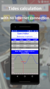
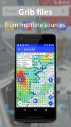
- آب و هوا و کسب فعلی قبل از عزیمت (فایل های grib ، نقشه های isobaric ، تصاویر ماهواره ای)
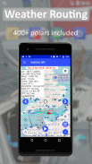
- مسیریابی: ناوبری خود را مطابق خواسته های خود بهینه کنید. از یکی از 400+ قطب ما استفاده کنید یا به سادگی قطعه خود را بسازید.
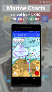
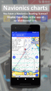
- نمودارها: در نمودارهای شطرنجی GeoGarage (SHOM ، UKHO ، NOAA ....) مشترک شوید یا از برنامه های Navionics Boating برای نمودارهای خود استفاده کنید.
- آب و هوای دریایی با Iridium Go! با بهینه سازی شدید برای به حداقل رساندن اندازه انتقال
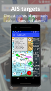
- AIS با آلارم
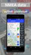
- ردیابی عملکرد با داده های NMEA شما
- آلارم ها
- سفرهای دریانوردی خود را با Navygatio (بتا) تجسم کنید ، به اشتراک بگذارید و تجزیه و تحلیل کنید
همه اینها با هزینه بسیار کم در مقایسه با راه حل های سنتی.
SailGrib WR در آوریل 2021 به عنوان "بهترین برنامه دریانوردی چند کاره با چندین ویژگی ضروری" توسط پلت فرم اجاره جهانی قایق Zizoo (https://www.zizoo.com/fa/m/best-sailing-apps-for قایق سواری-کروز)
SailGrib WR توسط بسیاری از ملوانان در مسابقات استفاده می شود: Vendée Globe (Armel Tripon) ، Figaro 3 ، Mini 650 ، IRC ...
توجه: اگر Virtual Regatta Offshore را بازی می کنید ، از SailGrib4VR برای مسیریابی خود استفاده کنید و برنامه های خود را مستقیماً به VR ارسال کنید. بسیار کارآمد است!
گزینه PREMIUM
- اشتراک Premium Option به مدت 1 ماه ، 12 ماه (تمدید خودکار) در دسترس است یا با پرداخت یک بار "مادام العمر" خریداری می شود.
- اشتراک حق بیمه به همه ویژگی های برنامه دسترسی می دهد.
- پس از تأیید خرید ، پرداخت از حساب Google Play کسر می شود.
- اشتراک به طور خودکار تمدید می شود.
- برای لغو اشتراک خود ، به برنامه فروشگاه Google Play بروید یا این پیوند را دنبال کنید: https://support.google.com/googleplay/answer/7018481؟co=GENIE.Platform٪3DDesktop&hl=fa
- اگر اشتراک خود را لغو کنید ، خدمات تا پایان دوره پولی در دسترس خواهد بود
راهنمای آنلاین: https://www.sailgrib.com/sailgrib_wr-support/
گروه کاربران FB: https://www.facebook.com/groups/sailgriben
Weather - Routing - Navigation - نسخه 8.1
(07-09-2024)Weather - Routing - Navigation - اطلاعات APK
نسخه APK: 8.1حزمة: com.sailgrib_wrآخرین نسخه Weather - Routing - Navigation
سایر نسخهها


اپلیکیشنها در دسته مشابه


